GEOTECHNICALENGINEERING
ST ALBERT ALBERTA
HomeUnderground ExcavationsGeotechnical design of deep excavations

Geotechnical Design of Deep Excavations in St. Albert

Site investigations you can build on.

LEARN MORE

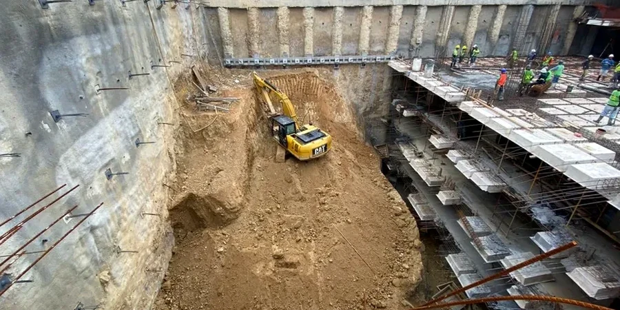
In St. Albert, any excavation deeper than 3 meters triggers specific requirements under the Alberta Building Code and NBCC 2015. The city sits on a complex layering of glacial Lake Edmonton sediments—stiff clays and tills that can stand vertically for a while but degrade fast once the water table kicks in near the Sturgeon River valley. We start every deep excavation project by mapping the stratigraphy with data from CPT testing to define the transition from dry till to saturated silt. That single boundary dictates whether a soldier pile wall will work or if you are looking at a tied-back secant system. Our team handles the full design cycle—from factual geotechnical reports to detailed shoring drawings—keeping the contractor’s schedule and the city’s permitting process in sync.

St. Albert's glacial till stands up until it doesn't—our designs account for the fissures and groundwater that change the game.

Our service areas

Our approach and scope

A common mistake we see in St. Albert is treating the hard clay till as bedrock and under-designing the lateral support. It is stiff, sure, but it is also preconsolidated and fissured. Once a crack opens up behind the wall, water gets in and the block failure risk multiplies. We design for this reality. Our approach combines finite element modeling with field-verified soil parameters—undrained shear strength from triaxial tests, Atterberg limits to confirm clay plasticity, and groundwater monitoring data that reflects seasonal highs in April and May. Shoring options range from cantilever soldier piles for shallower cuts to multi-level tieback systems when the excavation goes below 6 meters near existing infrastructure. Every design package includes a construction sequence, deflection estimates, and a monitoring trigger plan so the contractor knows exactly when to act.
Geotechnical Design of Deep Excavations in St. Albert
Technical reference — St Albert Alberta

Site-specific factors

St. Albert sits at roughly 665 meters above sea level, with the Sturgeon River cutting through the north side. That elevation drop means excavations near the valley slopes are working within a regional groundwater flow path—not just a static table. We have seen projects where a dewatering system designed for flat terrain pulls water from half a kilometer away, destabilizing slopes that were never part of the original risk assessment. The 2021 St. Albert geotechnical review highlighted several cases where adjacent residential foundations experienced settlement due to unplanned drawdown. Our designs include hydrogeological modeling that maps the cone of depression before a single pile is drilled, and we set piezometric trigger levels that shut down excavation if the drawdown extends beyond the predicted zone.

Need a geotechnical assessment?

Reply within 24h.

Email: info@geotechnicalengineering.vip

Reference standards

NBCC 2015 (National Building Code of Canada), CSA A23.3-14 Design of Concrete Structures, ASTM D2487 Unified Soil Classification, ASTM D1586 Standard Penetration Test, Alberta OH&S Code Part 24 (Excavating and Tunnelling)

Typical values

ParameterTypical value
Max design depthUp to 25 m below grade
Typical soil profileGlacial till over clay shale / silt
Shoring systemsSoldier pile, secant, tied-back, soil nail
Groundwater controlDeep wells, wellpoints, or cut-off walls
Analysis methodLimit equilibrium + FEM (Plaxis 2D/3D)
Deflection criteriaTypically H/200 to H/500 per adjacent structures
Monitoring includedInclinometers, piezometers, survey targets

Common questions

What depth of excavation requires a professional engineer's design in St. Albert?

Under the Alberta OH&S Code Part 24, any excavation deeper than 3 meters that a worker will enter must be designed and stamped by a professional engineer. In St. Albert, the city also requires a geotechnical report as part of the development permit for deep basements and underground parkades, especially near the Sturgeon River valley where groundwater is a factor.

How much does a deep excavation design typically cost in St. Albert?

For a typical St. Albert project, the geotechnical design package ranges from CA$3,290 for a straightforward soldier pile wall on a residential lot to around CA$9,920 for a complex multi-level tied-back system with full hydrogeological modeling. The scope includes soil parameter definition, shoring analysis, stamped drawings, and a monitoring plan.

How long does the design process take from start to permit-ready drawings?

A typical timeline is three to four weeks after we receive the site investigation data. If we are also managing the field investigation—say, CPT soundings and test pits—add another week or two. We can fast-track to two weeks for urgent projects when the soil conditions are already well-documented from nearby work.

What monitoring is required during excavation in St. Albert?

The city and the OH&S Code require monitoring when the excavation is near public infrastructure or adjacent buildings. We typically specify inclinometers behind the shoring wall to track deflection, piezometers to monitor groundwater drawdown, and optical survey points on neighboring foundations. Readings are taken daily during active excavation and weekly during standby periods, with defined trigger levels that require immediate review if exceeded.

Location and service area

We serve projects in St Albert Alberta and surrounding areas.

View larger map